Sunday, April 26, 2009

BOAT-TO-BOAT RECOGNITION

USS LIBERTY SIGHTS THE MTBS AND VICE-VERSA
Adam Larson / Caustic Logic
April 26 2009
last edit 5/2


When discussing the prolonged, coordinated IDF blitzkrieg attack on the USS Liberty, the whole “fog of war” “mistaken identity” explanation is routinely tossed out as the catch-all reason. Such people will easily suggest, essentially, that friendly fire incidents happens so often it’s a wonder anyone ever recognizes anything effectively when at war. I sense these theorists have entered their own fog once exposed to the details; the real IDF philosophy was apparently to misidentify the ship repeatedly at every turn, to start shooting immediately and keep shooting until you know who you’re shooting, and remain incredibly obtuse about figuring that out the whole way. Ain’t nothing friendly about that.

On the Liberty, in contrast, great care was taken to accurately identify the SoBs strafing and napalming her crew. Only one side in this battle seemed amazingly confused about what was going on, and the other was operating in the real world. “Fog” is more diffuse than this, bunching in spots of course, but only so densely, and drifting across lines in a natural flow. This is a proper zero-visibility “cloud front of war” - swift, heavy with storm, and driven out over the sea by some unseen wind, right ahead of the prime actors in what mechanically happened – the three motor torpedo boats (MTBs) that first tagged the Liberty for attack and very nearly sunk her.

FIRST CONTACT - BEFORE VISUAL
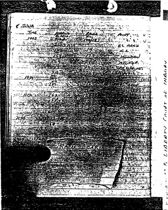
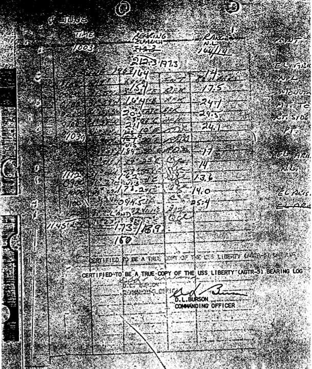
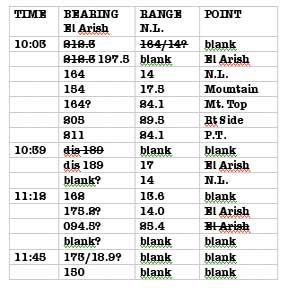
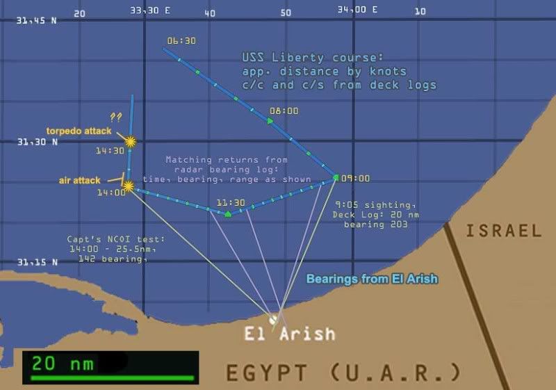
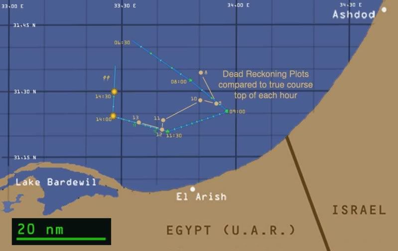
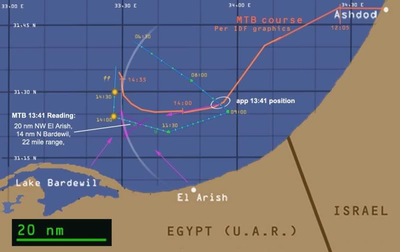
Designated Division 914, and code-named Pagoda, the three swift light craft were already well en route to the scene for an unspecified mission, when first alerted of their target at 13:30 [1]. It was of course framed as a suspect Egyptian warship, and shortly thereafter, at 13:41, they made first radar contact with some vessel at a range (distance) of 22 miles, almost due west of them [2]. Although what these returns told them [see below] has nothing to do with the Liberty, they were apparently what the hunters followed up to the prey.

Being the larger target, it makes sense the Liberty was seen first by the other party. She wasn’t long behind, however, and their radar operators spotted the smaller MTBs ten minutes later, at 13:51. This showed as three small surface craft, 16 nautical miles distant on a relative bearing of 82 degrees. [3] They had the correct location, number, and size of the targets, the proper bearing and range and presumably the right speed. These are the building blocks of proper identification by radar. But far from visual range, they had no ID yet nor any idea of hostility headed their way – it would be another five minutes or so before IDF jets appeared and started strafing.

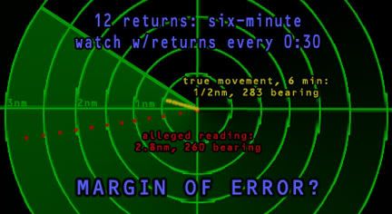
Now things were a lot more foggy on the Israeli end – apparently a side-effect of being on the offensive. This is the first of several mis-identifications, as the returns were somehow interpreted as showing the craft at 28-30 knots, nearly six time the Liberty’s actual speed. They also calculated, and double-checked, a significantly different initial heading than the Liberty was on, and a change of direction shortly after being spotted, which the Liberty also did not do. These incorrect calls brought in fighter planes to catch the apparent enemy ship speeding to Egyptian Port at Said, and slow it down with repeated air attacks from 1358-1411.

FACE-TO-FACE
It wasn’t until well after these attacks that the Liberty and the MTBs were within visual range, at about 14:20. Three small fast boats appeared, fitting the radar profile with no surprise. An apparently Israeli flag, small, but enough baby blue to guess, was seen from about 2000 yards, according to the Captain. "MTB believed to be flying Star of david flag. Flag quite small." [4] During closer passes, one badge number at least was noted in the Captain’s first situation after attack report: “Hull number of one boat was 206-17.” [5]

Ensign David Lucas was the one who made this call, and when asked about this entry during the Naval Court of Inquiry, explained the number was taken down from “approximately 500 yards.” Referring to a photograph in Jane’s Fighting Ships, perhaps the same one shown here, Lucas said it “appears to be the exact same one that I identified. If I had had a camera and taken a picture of it, I would have gotten the same angle, […] what I thought to be 17, I found out later from Mr. Bennett, when I examined this book, that it was an Israeli symbol.” [6]
In particular, it seems to be the Hebrew letter teit; the three boats of Division 914 are sometimes designated T-204, T-203, and T-206. The given length for these craft is about 93 feet, making the numbers about 2.5 feet high, and the total designation block about ten feet long, clearly visible from 500 yards. In comparison, the Liberty's overall GTR5 lettering block measured about twenty-five by ten feet, and would be visible from a much further distance.

On their way there, the MTB crew say they felt they were racing towards an Egyptian Z-Class destroyer, based on the shelling reports, the ‘observed’ radar speed, and even initial Air Force reports in the attack. When they got to it they quickly realized that was wrong. Israeli historian Michael Oren explained how Division Commander Moshe Oen (no relation?) "could see that it could not be the destroyer that had supposedly shelled El-Arish. Rather, he believed, it was a slower-moving vessel that had either serviced that destroyer or evacuated enemy soldiers from the beach.” [7] Thus any second thoughts this gave them were quickly corrected – it was just a different Arab ship. The important but overlooked corrolary of this is the IDF’s jets had already spent twenty minutes attacking the wrong vessel and the 30-knots shore attacker was slipping away behind the distraction. This seems, from the records I've examined (all available) to have been no concern of the IDF, as they continued their attack against the easy mark in lieu of a threat they seemed to know never really existed.

The MTB crew only had access to a slim volume detailing known vessels of surrounding Arab nations, leaving them clueless about the wide world of non-Arab vessels, like the one before them. [8] Looking for the best fit therein, they Michael Oren explained:
“Consulting his naval intelligence manual, [Commander Moshe Oren] concluded that the vessel in front of him - its deck line, midship bridge and smokestack - resembled the Egyptian freighter El-Quseir. The officers of the other two boats reached the same conclusion independently, and followed Oren into battle formation.” [9 - emph mine].
Simply “resembling” a possible enemy ship should never be a reason to attack; even if they were unable to gauge the Liberty’s true size and find it to be nearly twice the length and more than thrice the overall displacement of the one in their book, considering them equal in size, much did not fit. The giant middle mast must have been added along with numerous large antennae, the mid-ship structure had been built way up, the smokestack straightened and moved forward, portholes removed, and her overall shape significantly changed. [See also K.J. Halliwell's excellent analysis at the USS Liberty Inquiry site]. But otherwise, aside from the massive size difference, it definitely resembled the El Quseir. And if this was the closest fit they could find, the proper conclusion would be this was not an Arab ship at all. El Quseir, left and USS Liberty, not to scale. The numbers in the book and their own eyes gave them every chance to gauge the difference.

LIGHTS AND BULLETS
One method of gaining more information about the ship was, quite simply, to ask them, using internationally accepted light signals. Oren related the official Israeli version of the light conversation:
“At 6,000 meters, Oren's T-204 flagship paused and signaled "AA" - "identify yourself." Due to damaged equipment, McGonagle could only reply in kind, AA, with a hand-held Aldis lamp. Oren remembered receiving a similar response from the Egyptian destroyer Ibrahim al-Awwal, captured by the Israeli navy in the 1956 war, and was sure that he now faced an enemy ship.”[10]
The equipment was indeed damaged – all installed signal lights but one were shot away in the attack, by accident or design, leaving them with one tiny light six inches in diameter and nowhere near powerful enough to shine through the thick smoke roiling up from the air attack. [11] I’ve seen no evidence or reason to suspect the small light was only capable of signaling “AA.” And that's certainly not what the crew recalled sending.

Another source (Hank Roth) explained how crew member Udi Erell gave the signal as "AAA," but clearly "saw the response flickering through the smoke four miles away." [emph mine] Again the reference was made to this well-known indication of Egyptian bad-guy-ism, circa 1956. Their own identity was their best defense for the Liberty to throw out there, and in fact, the piece continues: "the Americans on the bridge of the Liberty would later state that the signals flashed were the ship's name and its international call sign, not what the Israelis believed they saw.” [12]

Oren’s article has the signaling done from 2.5 miles, Roth says four miles, and both agree that their signals were readable at that great distance, though the thick smoke, and so were the Liberty's responses. In fact, Captain McGonagle’s testimony to the Naval Court of inquiry seems to mean neither side signaled anything at this time, and common sense would indicate neither should be readable in the circumstances. First, he was asked when “the patrol boats were attempting to communicate with flashing light.”
“A. This was definitely after the torpedo attack.
Q. The flashing lights from the boats were after the torpedo attack?
A. Yes, that is correct. […] The first signaling that I observed was the unsuccessful attempts to determine what they were signaling us, and of course, we did not have a chance to answer back to them. This was after the torpedo attacks.
[13]

This implies the attackers made no attempt to communicate with the ship, which contradicts the MTB crew’s testimony. However it also goes against McGonagle’s own summary of event presented to the NCOIA Prior to the first shot, as the MTBs first sauntered up:
”When the boats reached an approximate range of 2,000 yards, the center boat of the formation was signaling to us. Also, at this range, it appeared that they were flying an Israeli flag. This was later verified. It was not possible to read the signals from the center torpedo boat because of the intermittent blocking of view by smoke and flames.” [14]
This is supported by the NCOI’s chronology from the deck log, putting these signals at 14:28, and the signaling distance as 2,000 feet, much closer than the Israelis stated. [15] This development was followed by the Captain's order to the guns to hold fire, which was followed by a few rounds fired by two guns. Personally I don’t buy the crew's story of how those guns started shooting, but that’s an aside. By jittery/pissed-off sailor, captain's order misunderstood, napalm-induced anomaly, or some combination, it happened. McGonagle understood “I am sure that [the MTBs] felt that they were under fire from USS LIBERTY. At this time, they opened fire with their gun mounts and in a matter of seconds, one torpedo was noted crossing astern of the ship at about 25 yards.” [16]

The MTB Log records “detected firing flashes” at 14:35, apparently taken as a negative response to their own flashing. They then recorded the identification as El Quiser at 14:37, and their counter-attack commencing at 14:40, first torpedo launched at 14:43. [17] On the other hand, the Liberty’s logs from the deck to the boiler room show machine gun fire on both sides at 14:30/31, the first torpedo miss at 14:34, and the unambiguous deep impact at 14:35. [18] These could be troubling contradictions or could just indicate the MTBs' clocks were 5-10 minutes ahead.

Roth’s source for the initial identifying signals from Liberty were apparently later ones sent at closer range, with a more powerful light rigged up after the torpedo attack. The Chief Communications Technician, Harold J. Thompson, related this exchange as “US Naval Ship - US Naval Ship.” “do you need help.” “no, thank you.” “Do you want us to standby?” “no, thank you.” “good luck.” [19] Captain McGonagle recalled on another occasion hoisting a flag meaning that steering was erratic and they should keep away. [20] There is much here to be confused about, but it seems likely the MTBs did signal prior to the attack, but they didn’t wait for - and perhaps didn't want - an answer.

HOW SLOW THE LEARNING CURVE?
So many clues were missed up to this point – the initial surprise on finding something other than the guilty destroyer, something too slow and unarmed, already over-attacked on the idea it was one. Time to re-think? No, being close enough to shoot, they also risked being close enough to see the 13-foot holiday colors US flag, well-extended as the Liberty was cruising into the wind by now. They could have seen the large hull lettering on the side, well below the obscuring deck fires, should have been visible from miles off. The pre-torpedo order from headquarters alerting the MTBs to hold fire, per confusion about the ID, failed to reach commander Oren. [21]

Eventually of course they did learn of the ship’s identity, but accounts differ as to what the final tip-off was and when it came. Michael Oren cites a cut-loose life raft as the first clue: “one of those rafts, picked up by T-203, was found to bear U.S. Navy markings - the first indication that Oren had that the ship might be American.” [emph mine] That certainly seems a clue worth considering, and apparently “his suspicions mounted when while circling the badly listing ship, Oren confronted the designation GTR-5. But still no flag was spotted, and it would take another half an hour, until 3:30 p.m., to establish the vessel's identity.” [22]

This all was occurring, then, around 15:00, 25 minutes after the torpedo hit. The deck log and NCOI chronology places the light signals regarding assistance at 15:03, the time they were told that they’d just attacked a “US Naval Ship.” Still unsure, as Roth explained “drawing closer to the burning vessel, they were able to make out a flag. It was not opened by a breeze and could not immediately be identified, but it was clearly not Egyptian." What could it be? Crewmember Udi Erell “saw a splash of red on the flag and heard a report being sent back to Haifa that the vessel might be Russian.” [23] Since Egypt’s flag is three solid stripes of black, white and red, and the Soviet flag is almost nothing but red, a simple “splash” should have been enough to cause yet more concern, on top of the US rafts and non-Arabic, non-Cyrillic lettering, and the crew insisting they were Americans. "Dang, this keeps getting more confusing. Hey you guys, I know this sounds crazy, but… what if these guys are Americans?"

Shlomo Erell was the IDF Navy’s chief of staff, and had been out of the office during the horribly bungled attack, and only heard about it after the shooting was done. Upon his return to the loop, things started making sense again. Erell later recalled reports on the flag, presumably from his son Udi’s commander in Division 914, Moshe Oren. “It was clear to me she couldn’t have made 28 knots and so I asked for definite identification. Then they reported the flag was going up, and being hoisted. Then the first identification was Soviet [chuckles] so I said come closer, he came closer, and identified it as an American ship.” [24]

The American flag they’d be seeing was the large “holiday colors” McGonnagle testified were raised as soon as the MTBs came into view, well before the torpedoing, and over an hour before the attackers finally noticed it. There is no record of a flag, other than the one about steering, going up anytime after this, so any memory of seeing the stars and stripes rising is impossible. So in case it sounded hyperbolic at the beginning, let me recap: the IDF philosophy here seems to be misidentify the ship at every turn, start shooting immediately and keep shooting until you know who you’re shooting, and remain incredibly obtuse about figuring that out the whole way.

Sources:
[1], [3], [15], [18] US Naval Court of Inquiry Exhibit 27: Chronology of Events. Found in a PDF document available here: http://www.thelibertyincident.com/docs/timeline.pdf
[2] Algon, IDF, 1982. http://www.gtr5.com/evidence/idfhr.htm
[4] USS Liberty Deck Log – logs 1-24, pp 14 in this packet: http://www.thelibertyincident.com/docs/Logs1-24.pdf
[5] McGonagle, William. Captain, USN. Situation Following Air Attack. Navy message. Filed 8 June 1967, 5:15PM UTC.
http://www.nsa.gov/public_info/_files/uss_liberty/liberty_messages/situation_following_attack.pdf
[6] Naval Court of Inquiry, record of proceedings, page 27. http://www.gtr5.com/evidence/ncoi.pdf
[7], [9], [10], [21], [22] Oren, Michael B. The 'USS Liberty': Case Closed. Azure, Spring 2000. http://web.archive.org/web/20000917231200/http://www.azure.org.il/9-Oren.htm
[8]http://www.thelibertyincident.com/ship-ident.html
[11]. [13] See 6, p 34.
[12], [23] Article re-published by Liberty Survivors Association as "Hank Roth, Israeli Apologist." Jan 20 1997 http://www.ussliberty.org/roth.htm
[14], [16] See 6, p 44
[17] Division 914 War Log. http://www.thelibertyincident.com/israellogs.html
[19] See 6, p. 88
[20] See 3, p 22
[24] Dead in the Water. BBC Documentary, 2002. Christopher Mitchell Dir. around 35:00 mark in this apparent 2006 update: http://video.google.com/videoplay?docid=-3319663041501647311

Wednesday, April 22, 2009

USS LIBERTY LOGS ANALYSIS

AND OTHER PRIMARY SOURCES
Adam Larson / Caustic Logic
April 22 2009
working copy - incomplete


I'm starting this post to keep track of what I learn from the USS Liberty's official mission-related paperwork and other primary sources. The main exhibit here is the deck log, which I found at this site [second packet, PDF]. These were filed along with other ships' logs as evidence for the Navy's Liberty attack court of inquiry (NCOI), whose final report is another prime source. My first point of interest was to find radar logs in particular, or anything showing whether or not other vessels were recorded around them before the attack. So far it doesn't seem so, but I have some sorted data worth sharing.


[r-click, new window for full view]
As you can see, these have not held up too well in the copying regimen. The first page is a hand-held photo of the bearing log, with a thumb and a scrap of paper covering half the page. The second is a flat 'scan,' which is more uniformly readable except that it was apparently written on tracing paper which here is over a lat-long graph. It's a bizarre effect, and a bit unprofessional, it seems, for a Navy court of inquiry. Trying to sort it out, I decided the lat-long one runs hourly from 00:00(midnight) through 13:00. Apparently they got distracted sometime before the 1400 entry. It's simply time, lat, long, INT (initials), and ??? column, left blank anyway. A large portion of the entries are obscured, others simply unreadable at this exposure and resolution. And I'm sure the data is available elsewhere and of no huge interest. [Update: K.J. Halliwell's got a perfectly clear copy of this available as the 'dead reckoning chart'here.]
The overlay is the log I'm interested in, without the covering paper or thumb, and we see nothing was missing except "Certified to be a true copy of the USS Liberty (AGR-5) Bearing Log." Transcribed at left, this only shows navigational use of radar - taking bearings on land objects (usually the minaret at El-Arish), and nearest shoreline along that line. Time intervals are apparently ten minutes per line on average, only sporadically labeled, screwy at the beginning. Since the steady course at five knots means one nautical mile was passed every twelve minutes, that may be the interval here. Either way, the last line with no point or range but a bearing of 150, would correspond with 11:50-12:00 depending. End-of-shift sloppiness? I don't see any further logs showing activity in the PM. I'm currently using these to fine tune my map of the route taken, and will post it when complete.

Capt McGonagle to the NCOI Confirmation that the bearing log from 12:00 on is not "available."
"LTJG PAINTER came onto the bridge after general quarters to assume the watch as the officer of the deck. As he assumed the officer of the deck watch, he indicated that he was having difficulty in obtaining an accurate ship's fix. At that time, and the time was approximately 1400, I personally sighted the Minaret at El Arish to be on a bearing of 142 from the ship and the range as I recall from the radar was approximately 25.5 miles. I do not know that this radar range can be verified from the records available at this time."


For visibility range, we have Ensign David Lucas, who was apparently in charge of surface lookouts, and told the NCOI between 1200 and 1300, “more smoke was visible and the land itself was barely visible. This was through the telescope or high powered binoculars on the 04 level.” Nearest Land was about 20 nm distant, first less then more, during this time. Regarding sightings of ships, which would be more challenging than spotting the edge of a continent:
"[The lookouts] had received refresher training, this was sometime since we left Rota on the 2nd of June, and had been refreshed on reporting all surface contacts to include relative bearing, approximate range, and target angle. Had also been given refreshers on reporting aircraft properly, on elevation, what angle, other factors pertaining to properly reporting all surface and air contacts to the officer of the deck. This had been stressed heavily in the first week in June, before we did reach our operating area.”
Officer of the deck's notes [packet 2, pp 3-4] show no reports of surface craft on June 8 prior to the attack. The main deck log does mention two ships sighted June 7, in this same vigilant mode:
1420 sighted unidentified merchant ship bearing 198, distance about 4800 yards. Identified asmerchant ship as Bencleugh, registry unknown. […] 1430 sighted merchant ship Ioanis Asptiotis Greek registry, bearing 019, distance about 1500 yards.
These were about 2.37nm and 0.74nm distant. There were almost certainly other ships around further out, but these were apparently too far away to notice or care about. The smaller torpedo boats were first sighted at an estimated distance of 3-4 nm. So lack of visual contact is not much of a problem for a mystery ship unless it was supposed to be less than four miles from Liberty.

But their radar had a range of up to 24.5 miles anyway, judging by ranges given in the chart (I'm pretty sure now my 29.5 above should be 24.5). This was for a large object called "nearest land (N.L.), not a piddling warship. The Liberty's radar did pick up the approaching MTBs at 1351, ten minutes after the latter has detected them, and six minutes prior to the air attack: "1351 [LOG:] 3 SMALL SURFACE CONTACTS HELD ON RADAR 32,000 YARDS BEARING 082T - REPORTED TO BRIDGE AS 3 SURFACE CONTACTS." [Source: MTB Torpedo Attack - testimony].If these smallish boats (about 90 feet long) appeared at this range, a ship of any size then would have to be probably 20 nm away or further to not show on radar.

ATTACK MAPS BASED ON OFFICIAL SOURCES
[r-click, new window for full-size view] USS Liberty course from 6 am until the end of the attack. 20 nautical mile scale, land contours from Google maps, lat long intersections set using Earth Tools. Path first set roughly from various graphics. Liberty speed and course changes derived from the Deck Log, lengths of each leg set by knots, marked at 15 min intervals. All approximate, and ignoring small momentary changes. 9:00-11:30 stretch fine-tuned with Liberty's radar bearing log and its readings from El Arish minaret, plus deck log (9:00 entry) and captain's recollection (14:00, as above).
I hoped the plots from the Dead Reckoning Table would help pin down the exact course, but no luck.
Motor Torpedo boats app. path based on IDF graphics, generally supported by MTB logs. Location of their radar return at 13:41 (inside the magenta triangle) matches the Liberty, but the heading and speed they decided on were way off, which remains an unresolved mystery.

Friday, April 17, 2009

USS LIBERTY MYSTERY SHIP INQUIRY

ADDITIONAL RESEARCH
Adam Larson / Caustic Logic
April 16 2009
working copy - incomplete


This post, to be updated regularly, will condense various evidence supporting the tentative hypothesis of a previous post The One That Got Away? Essentially, it's a look at the circumstantial evidence for a second, and belligerent war ship in the vicinity of the Liberty prior to its attack - the provoker and cause of the troubles that fell on the American kids. Considering the possibly explosive nature of this, questions about the sources and verification, and lack of previous studies on it (that I know of), I'm forced to be deeply intrigued. And as I look, I'm uncannily confirmed that there's something more than coincidence at work here. Following are the four operative aspects: seriousness of shelling reports, claims of two ships in the vicinity (Israeli Defense Force reports), second ship evidence from Liberty crew, and finally the puncher: speed and heading "errors" in what's supposed to have been the Liberty's track. At the end, a graphic summation. If there weren't at least two separate target ships involved in this episode, someone is trying to make it appear so.

1) SERIOUSNESS OF SHELLING REPORTS
From the IDF Ram Ron Report, 6/16/67:
"At 11.24 a.m. a message was received from the Command Post and by the Air Force that El-Arish was under bombardment from the sea. This message was transmitted on the basis of a message received from the Southern Command and had been repeated several times - based on repeated similar messages from the Southern Command.
[...]
These messages when reported to Capt. Rahav by Comm. A. were received by him with reservation and he insisted that they be re-examined. […] Together with his demand that the information regarding the shelling be verified, Capt. Rahav instructed Comm. A. at 12.05 p.m. to order three torpedo boats then stationed at Ashdod and ready to sail, to head in the direction of El-Arish in order to investigate the information received. Lieut. Comm. P. re-investigated the information regarding the shelling with the Naval Forces Command Post and was informed again that the Southern Command reports that El-Arish is under bombardment from the sea…
[…]
At 13.17 p.m. Comm. S. (representative of the Naval Force at the Command Post) advised Comm. A. that El-Arish
had been under bombardment for the last four hours. Following this message, Comm. A. ordered Comm. AR. - Division Commander/Torpedo Boats - to examine the area at approximately 20 miles north of El-Arish.”
From Col. Uri Algom, The Attack on the "Liberty" Incident: 8 June 1967. IDF History Department, 1982. Posted here.
"At 1124 hours, the naval representative at Air Command reported to Naval Operation Section/3, on the shelling of El-Arish from the sea, Commander Lunz passed on the report to Chief of Naval Operations, Captain (Navy) Rahav, and he to turn instructed Lt. Commander Pinchasi, in no uncertain terms, to check the source of the report. The inquiry into the source of the report was ordered because of the many reports which had been received concerning shelling from the sea and which were later proven to be false, The feeling was that this report was probably no different. Lt. Commander Pinchasi was told by Air Operations Section/3 that the source of the report was an Air-Ground Support Officer in El-Arish; the Navy representative at the Supreme Command, Lt. Commander Tel, also informed Lt. Commander Pinchasi that a similar report had been received enquiry to Naval Operations/3.

Meanwhile the shelling of the coastline also aroused interest at Supreme Command. The Head of Operations Section, Lt, Colonel Haim Nadel, (during a meeting with the COS at 1127 hours), received a report from G Branch- Southern Command, stating that
a ship had been shelling El-Arish but the shells had not reached the coast. The Head of Operations Section immediately ordered that the report be verified, and more important instituted a check to see if there were no Israel Navy vessels off the coast of El-Arish. [...] These reports were passed to Fleet Operations Control Center - to Commander Lunz and Captain (Navy) Rahav. The accumulation of reports from various sources and the involvement of Supreme Commend in the matter, indicated that these reports were not baseless and should be taken seriously."
Michael B. Oren, The USS Liberty: Case Closed. Azure. Spring 2000:
"Then, at 11:24, a terrific explosion rocked the shores of El-Arish. The blast was clearly heard by the men on the Liberty's bridge [...] In El-Arish itself, Israeli forces were convinced they were being bombarded from the sea [...] Though the explosion probably resulted from an ammunition dump fire, that fact was unknown at the time [...there was] good reason to conclude that the Egyptian navy had trained its guns on Sinai."

Captain McGonagle, testimony to Naval Court of Inquiry:
“[I]t was possible to see a large billowing cloud of black smoke rising from approximately 15 to 20 miles to the west of El Arish on the beach. The exact identity of the cause and the location of this explosion is not positively known, although it was believed to be near the beach in that area. This was noted at about 1300. At about 1330 a smaller cloud of black smoke was noted to the east of El Arish estimated five to six miles and also along the coastline."

Two separate plumes miles apart does not sound like a simple ammunition dump fire. It's interesting to note Israeli command seemed confident the explosions were caused by a vessel north of El Arish, while the Liberty, on the scene in that area seemed oblivious to any such presence near them. The danger was distant, but noted by the Captain at about 1:45 as the drill wrapped up, about 10-15 minutes before the first strafing run across the deck:
"Before dismissing the crew from general drills, I gave the crew a short talk on the PA system, reminding them of the importance of expeditiously responding to general quarters and the setting of condition Zebra for drills and in the event of an actual attack. So that they would be impressed I pointed out to the crew at that time that the column of black smoke on the beach should be sufficient evidence that the ship was in a potentially dangerous location.”

2) TWO SHIPS IN THE VICINITY (IDF REPORTS)
Of course, any explicit mention of a ship seen or known to be shelling indicates a ship capable of that, in addition to the Liberty. With that in mind:
From the Yerushalmi Report, 7/21/67:
"It is to be noted that the reports from Southern Command [re: shelling] were also accompanied by information that two vessels had been observed approaching the coast."
From Algom, IDF, 1982:
"The Head of Operations Section, Lt, Colonel Haim Nadel, (during a meeting with the COS at 1127 hours), received a report from G Branch- Southern Command, stating that a ship had been shelling El-Arish but the shells had not reached the coast. [...] Meanwhile, another report arrived from Southern Command (at 1145 hours), which stated that two ships were approaching the EL-Arish coast."
Note: The Liberty was approaching the coast, obliquely from the east, until 11:30, and then turned slightly away. If any report specifying "two ships" came in, it could be concocted, out of caution or something else, from duplicate but differing sightings of the lonely Liberty. It's also possible they originated with an aerial reconnaissance round that observed both the Liberty and a specific second ship, or even two mystery ships aside from her, thus confidently reporting "two ships." Another possibility:
Ram Ron Report:
"Said messages also contained reports on two ships or one ship shelling El-Arish [...] Naval Forces Command Post and was informed again that the Southern Command reports that El-Arish is under bombardment from the sea and that two ships can be seen at a distance."

Very important bit from Oren's article I missed at first indicates there was at least a brief moment the Motor Torpedo Boat commander felt there were two ship in the area, worked out for a separate post:
On their way there, the MTB crew say they felt they were racing towards an Egyptian Z-Class destroyer, based on the shelling reports, the ‘observed’ radar speed, and even initial Air Force reports in the attack. When they got to it they quickly realized that was wrong. Israeli historian Michael Oren explained how Division Commander Moshe Oen (no relation?) "could see that it could not be the destroyer that had supposedly shelled El-Arish. Rather, he believed, it was a slower-moving vessel that had either serviced that destroyer or evacuated enemy soldiers from the beach.” Thus any second thoughts this gave them were quickly corrected – it was just a different Arab ship. The important but overlooked corrolary of this is the IDF’s jets had already spent twenty minutes attacking the wrong vessel and the 30-knots shore attacker was slipping away behind the distraction. This seems, from the records I've examined (all available) to have been no concern of the IDF, as they continued their attack against the easy mark in lieu of a threat they seemed to know never really existed.

3) POSSIBLE SECOND SHIP REFERENCE (USS LIBERTY)
This is certainly the weak point of this theory: no eyewitness or radar reports of any suspicious ship zipping at 30 kts through their space. As mentioned in the original piece, Survivor Richard Carlson wrote this, which might be a clue, vague as it is:
"I had finished lunch, and now standing by the starboard railing, began talking with CT1 Bingham. He looked as nervous as I felt. We tried to console each other that we were basically an unarmed ship, in international waters, and that no one was going to bother with us. Neither of us sounded convincing. We couldn't seem to shake the mystery ship following us. Who was it we wondered?"

That's just nothing much to go on. I'm starting a separate post to explore primary sources on what 'the ship' as a whole might have seen. Nothing yet about any steel-and-oil mystery ship, but a little more room than I thought for it to hide in, hypothetically at least, and some useful information otherwise.

4) SPEED AND DIRECTION "MISCALCULATION"
From the US State Department, Salans Memorandum, 9/21/67:
"As you requested, we have compared the decision of the Israeli Judge, dated July 21, 1967, with the findings of the U.S. Navy Court of Inquiry, and the Clifford Report, concerning the Liberty incident. The following discrepancies are noteworthy:

I. Speed and Direction of the "Liberty"
The Israeli report indicates that the torpedo boat Division Commander reported and reconfirmed the target's (Liberty's) speed at 28 to 30 knots and that it had changed its navigational direction shortly after 1341 hours.
The U.S. Navy inquiry established that the Liberty had been on a steady course at 5 knots from 1132 hours until the attack."
Note the target in question was first sighted at 1341, a fact communicated back to headquarters. What would cause this ship to change direction shortly after discovery? "Whiskey Tango Foxtrot, you are on the scopes now. Depart the area, full speed."
Ram Ron Report:
"At 13.41 p.m. the Torpedo boat's radar picked up a target at a distance of approximately 20 miles north/west of El-Arish and approximately 14 miles north of Barbville [sic]. Immediate message to the effect was passed on to Comm. A. [...] At 13.47 it was reported from the Torpedo Boats that the speed of the unidentified targets was 30 knots and their course 260. […] at 13.50 p.m. the Torpedo boats reported that the target speed was 28 knots."
Yerushalmi Report:
"According to the division log-book, a target was located at 13.41 hours situated at a distance of about 20 miles north of El-Arish. The division was ordered "to close in and identify the target," and reported that the unidentified target was moving at a speed of 30 knots westwards--that is, in the direction of Port Said.

A few minutes later, the Division Commander reported that the target, now 17 miles from him, was moving at a speed of 28 knots, and since he could not overtake it, he requested the dispatch of aircraft towards it. The Division Commander also reported that the target had changed its navigational direction."
Note the direction of change and its implications are not specified, but considering the MTB path after this discovery (see graphic below) they decided it was turning north, which it in fact did about fifteen minutes later. The MTBs themselves turned soft right/north, apparently slowed down a bit, and eventually sort of merging with the Liberty's mid-speed escape path, and strangely failed to kill everyone, as they well could have.
From Algon, IDF, 1982
"At 1341 hours, the Division detected the target on its radar 20 miles northwest of El Arish and 14 miles off the coast of Bardewil. The officer at the C1C on the flagship, Ensign Yifrach Aharon, reported that the target had been detected at a range of 22 miles, that her speed had been tracked for a few minutes, after which he had determined that the target was moving westward at a speed of 30 knots. These data were forwarded to the Fleet Operations Control Center.

The speed of the target detected by the Israel Naval Division was significant in that it indicated, beyond doubt, that the target was a combat vessel - since only combat ships can develop such high speeds. [...] The given data created the impression at Naval Operations of an enemy ship, turning to escape in the direction of Port Said. The Chief of Naval Operations asked the Division to double-check their calculations. A second check confirmed the direction of the target, but her speed was corrected to 28 knots."
This report was offered by the IDF as the "official" Israeli version, their chance to set the record straight with full access to the knowledge of the Israeli Defense Forces to offer the best explanation of why their equipment might misread the situation so wildly. Please carefully consider the following, which is apparently the best Algon and his staff were able to come up with:
"In retrospect, it is clear that the data dealing with target speed were incorrect since the "Liberty" was not capable of cruising at such high speeds. However, it is astounding that the same target speed was measured independently by two torpedo boats: T204 (with the Division commander aboard) and T203 which estimated target speed at 25 - 28 knots."
It's "astounding," and that's comparing it to the non-sequitur top-speed of 18 knots. That's the "since." So even presuming the captain and crew and logs were all lying and she was flooring it to 18 there, a double-reading of 25-38/30 knots would be "astounding." That's pretty damn lame considering the Liberty was actually crawling along at less than a third of this, f-i-v-e nautical miles per hour, the whole time, which is the fact the author chose NOT to place after the "since." And there, ladies and gentlemen, is the IDF's best explanation. Another author using the same 'since' and nudging forth the IDF's implied whole other ship story:
Oren, Case Closed: "At 1:41 p.m., Ensign Aharon Yifrah, combat information officer aboard the flagship of these torpedo boats, T-204, informed its captain, Cmdr. Moshe Oren, that an unidentified ship had been sighted northeast of El-Arish at a range of 22 miles. The ship was sailing toward Egypt at a speed, Yifrah estimated, of 30 knots.

Yifrah's assessment, twice recalculated and confirmed by him, was pivotal. It meant that the ship could not be the Liberty, whose maximum speed was 18 knots. [...] This information, when added to the ship's direction, indicated that the target was an enemy destroyer fleeing toward port after having shelled El-Arish.

The torpedo boats gave chase, but even at their maximum speed of 36 knots [actually 42 -ed], they did not expect to overtake their target before it reached Egypt [based on the 560% wrong speed 'calculation' -ed]. Rahav therefore alerted the air force, and two Mirage III fighters were diverted [...] [and the hits just kept coming -ed]."

GRAPHIC SUMMATION
Coming back when it's corrected. Yep, I did something wrong. (Statute miles compared to nautical mils will give you 'discrepancies'). Slap head... still, it's a start towards mapping out the scene.

Wednesday, April 15, 2009

THE ONE THAT GOT AWAY?

THE USS LIBERTY’S MYSTERIOUS COUNTERPART
Adam Larson / Caustic Logic
April 15 2009 [last edit 4/19]


WRONG SIXFOLD?
Among the many reasons given by the Israelis for the USS Liberty mistake, over four decades ago now, is a report concerning the unarmed US spy ship’s speed. This is crucial, since standing orders for the Navy were to regard as hostile any ship traveling over 20 knots – warship speed. The Liberty, incapable of more than 17 or18 knots, should have been safe from any speeding-induced confrontations even though it was making its circuit just off the Sinai coast war zone.

According to Captain McGonnagle, the ship was on a course set around 11:30am and maintained until the attack - 283° degree heading, slightly north of west, and a leisurely 5 knots pace. [1] The Liberty was navigating by the minaret et El Arish 15 miles distant, then under Israeli control. Around 1 pm the captain noticed a massive plume of smoke from the distant shore a ways west of El Arish, then another just east of the city. He later testified:
"So that they would be impressed I pointed out to the crew at that time that the column of black smoke on the beach should be sufficient evidence that the ship was in a potentially dangerous location." [2]

These explosions, according to Isreali records, starting happening shortly before 11:30, and soon urgent and repeated reports started flooding IDF headquarters – the cause was believed to be shelling of the area by a warship. This concern prompted an order from Naval general headquarters for a sortie to find and punish the ship that was shooting at them. Squadron 914, code-name Pagoda, consisted of three motor torpedo boats (MTBs), each with a crew of 15 and two torpedoes. Led by commander Moshe Oren, they took off to the southwest at 12:05 pm. [3 – general source for the below as well]

The first thing they found was a radar track, locked in around 1:40, of a ship about 20 miles ahead. They got enough to plot a basic course – west-southwest towards the main Egyptian coast – and a speed of 30 knots. So important was this point that Oren ordered it double-checked, and the speed was refined to 28 knots. This looked like fair game – but too fair; the mystery ship was moving close to the MTBs top speed, meaning they could never catch up before it reached shore. So they let it go but put in a call for air recon to follow it, which somehow turned into a three-phase aerial attack on the virtually motionless Liberty.

Aside from their massive blunder of later misidentifying the Liberty as the El Quseir (a size factor of three), their inability to read hull markings or see flags clearly, to receive important orders like 'don't sink that ship yet...', this error in speed (a factor of six, and double-checked equally wrong), in particular casts an air of absolute farce on the Torpedo boat crew's explanation.

The well-made if reaching 2001 BBC documentary Dead in the Water explained – incredulously – the accepted story that these Naval experts grossly misread the Liberty’s speed. They cite the one crew member they were able to talk to – Udi Erell – who, for what it’s worth, is the son of the Navy Minister at the time, Shlomo Erell, and has become the public face of this tragic operation. He explains the speed discrepancy as the result of an overly short sampling, leading to what he calls “a very normal mistake.” The range of error from this could be “anything between, going backwards, and thirty knots forward.” [4] By this, it seems possible to misread a stationary ship as moving at 30 knots, which would then explain the Liberty’s 5 knot crawl showing up that way.

OREN’S SECOND SHIP
As the “Salans report” puts it, “the implication of such reports [of naval shelling] was obviously that a ship capable of such shelling was present in the immediate offshore area, i.e., within gun range of the shore.” [5] And a faster warship would also be necessary to be seen cruising at 30 knots. But a gross misreading must be the explanation, since all official stories cite the Liberty at only 5 knots and all reputable sources agree there were no such ships in the area – or do they?

Another view is quite intriguing, makes a lot more sense, and gives more credit to the MTB crews’ intelligence. It’s a version I’ve never heard stated explicitly, but it was strongly hinted at by, of all people, Israeli-American historian Michael B. Oren, who seems confident nothing but mistake was at work in the Liberty attack, and is frequently cited to that effect. Presumably of no direct relation to the MTB commander, Oren's excellent 2000 analysis The USS Liberty: Case Closed, he’s tipped me off to another clue that might just help keep the case open.

At 1:41 p.m., Ensign Aharon Yifrah, aboard the flagship of these torpedo boats, T-204, informed its captain, Cmdr. Moshe Oren, that an unidentified ship had been sighted northeast of El-Arish at a range of 22 miles. The ship was sailing toward Egypt at a speed, Yifrah estimated, of 30 knots. Yifrah's assessment, twice recalculated and confirmed by him, was pivotal. It meant that the ship could not be the Liberty, whose maximum speed was 18 knots.” [6 - emph mine]

Well holy cow, that’s an ingenious inversion of the usual story – what if the reading was right and they were seeing a different ship? It’s a leap he hasn’t necessarily made, but there it is to be taken, and it’s got a ring to it. “When added to the ship's direction,” Oren adds, the speed “indicated that the target was an enemy destroyer fleeing toward port after having shelled El-Arish.” He never draws this conclusion outright, but based on these clues, they may just have identified a destroyer that had been shooting at them and was fleeing the scene at high speed, a classic sign of a guilty conscience.

Supporting this non-explicit construct, Oren’s report also mentioned the improbable official explanation for the prolonged reports of shelling that had the MTBs sent out and all this drama set up. “Though the explosion probably resulted from an ammunition dump fire, that fact was unknown at the time” Or, not that I’d ask Oren to go there, it could just be that that excuse hadn’t been fabricated yet. The concerns sound a little more substantiated than jumpy response to fireworks going off. “In El-Arish itself,” Oren continues, “Israeli forces were convinced they were being bombarded from the sea, and the IDF Southern Command reported sighting two unidentified vessels close offshore.” [7 – emph. mine]

CONFIRMATION OF MYSTERY SHIP
Two vessels in the area, as well as indications of actual shelling, is supported by an Isreali Defense Forces report from a week after the attack:
At 11.24 a.m. a message was received from the Command Post and by the Air Force that El-Arish was under bombardment from the sea. This message was transmitted on the basis of a message received from the Southern Command and had been repeated several times - based on repeated similar messages from the Southern Command. Said messages also contained reports on two ships or one ship shelling El-Arish. [8 – emph. mine]

These tidbits show if multiple channels were reporting shelling, there may be more going on than a single fire with random explosions. If there were indeed two ships around there, and Liberty to my knowledge did not see this neighbor (see below), they must have been several miles from each other. If two ships were seen at such range, aerial recon would be the way, and Air Force is a cited source. As it’s hard to imagine someone correlating two separate sightings into a single two-ship report, a single pilot who saw both ships on the same flight seems most likely.

Indeed, non-attacking over-flights were reported by Liberty crewmembers at 10:56, 11:26, 11:45, 12:20, and 12:45. It can and has been contested these were not reconnaissance flights focusing on the Liberty. In fact, they almost seem to have explicitly ignored it; according to Oren, IDF records show no aerial reports regarding the Liberty after 9:00 am. But as the shelling reports came in we have at least one likely report mentioning two ships, and one has to be the doomed spy ship.

Searching for Liberty crew recollections for any hint of nearby ships before the attack on them, I found survivor Richard Carlson mentioning, a few days earlier "traffic on the Med was busy. Freighters and ships from all nations. It was fascinating to be sailing in this arena until we spotted three Soviet destroyers matching our course and speed to the starboard of us.” [9] Oddly, he also recalls a Soviet spy ship trying to physically block their entry at Gibralter. Unless the culprit was Soviet, which is an intriguing thought, this just clutters the picture; the trailing destroyers were long-gone by the point he recalls, around lunchtime on June 8: “We couldn’t seem to shake the mystery ship following us. Who was it we wondered?” [10 - emph mine] With no additional clues aside from feelings of apprehension, this could as well be a metaphorical ship of anxiety as the steel-bellied one I’m wondering about. It's worth further exploration.

THE GETAWAY AND THE SCAPEGOAT
But it seems quite possible there were indeed two ships in the area as the shore sustained damage that mid-day – it would appear one was shooting and was soon clocked by the Pagoda crew around quarter of two, the other took the blame and was mauled by successive aerial assaults over the next half hour. Since the airplanes had already marked it enemy by attacking, the same MTBs that had been unable to catch up to the suspect 45 minutes earlier followed with the attempt to sink it… that darn Arab ship must’ve slowed way down as soon as it got out of view… and got a “splash of red” on its flag.

We’re not sure of what this mystery ship was or what happened to it after it was last observed by Oren, Erell and company. It may have had guns capable of shelling the shore, it apparently was doing so, it was moving at warship speed. What happened next with the airplanes and the Liberty is outside their jurisdiction, but it may be the torpedo boats' first act of the day was to unwittingly preside over the getaway as the mystery ship slipped into the mists of time, pulling a wave of blitzkrieg wrath onto the innocent bystanders left lingering in the way.

UPDATE:
If you find this lead at all intriguing, please see my subsequent, in-the-works further analysis of the evidence.
---
Sources:
[1] Testimony of William L. McGonagle, U. S. Navy, Commanding Officer, USS LIBERTY. US Naval Court of Inquiry. http://www.ussliberty.org/ncitext.htm
[2] Ibid.
[3] Oren, Michael B. The 'USS Liberty': Case Closed. Azure, Spring 2000. http://web.archive.org/web/20000917231200/http://www.azure.org.il/9-Oren.htm
[4]Dead In The Water. BBC films. 2006 update viewable here - part in question around 33:30
[5]US Department of State. Memorandum by legal counsel Carl F. Salans. September 21, 1967. http://www.gtr5.com/evidence/salans.htm
[6] See 3.
[7] Col. Ram Ron. June 16 1967. http://www.gtr5.com/evidence/ramron.htm
[8]
[9] Carlson http://www.ussliberty.org/carlson.htm
[10] ibid
[11]

Friday, April 3, 2009

WALKING RIGHT ACROSS THE BROKEN CODE STORY

Adam Larson / Caustic Logic
The 12/7-9/11 Treadmill and Beyond
April 3 2009


KEEPER OF SECRETS
JN-25 is the name given by US cryptanalysts to the Imperial Japanese Navy’s main operational code in 1941. More precisely, it was JN-25B, the second incarnation introduced in Dec 1940 (it was called “AN’ code at the time, and has also been referred to as “5-numeral” code, or variants thereof). A sophisticated code-and-cipher system, JN-25 was based on 5-number groups directly representing words, enciphered with random additives to scramble the number groups. It effectively concealed hundreds of thousands of intercepted IJN messages with among the most vital clues available to Japanese intentions. They believed it unbreakable, but it was finally cracked in spring 1942, helping turn the tide of the Pacific War from the Battle of Midway onward

JN-25-encoded messages include the November 1941 transmission of plans for the Pearl Harbor attack – actually a three-week-long string of communications outlining all the details multiple times in different ways. Whether these messages ever were transmitted by radio is itself an unanswered question, to my knowledge. Most sources, reputable and otherwise, seem to presume it was, but with surprisingly little reason given (I’ll try to settle this at another time). If it were sent on radio waves it would be open to interception, which would put it at the mercy of the cryptographers and code-breakers and offered every clue one would need to fully prepare for the battle of Pearl Harbor

How well the secrets would hold up at that level is a matter of some controversy – the body of evidence supports the general accepted stance that the code was at least partly recoverable, and some 10-15% of this was readable as of November 1941 (different aspects of it changed frequently, including at the end and beginning of that month). Some revisionists have suspected the code may have been completely broken by US analysts prior to December 7, and a few have gone so far as to claim to have proven this – that the intent of the Japanese force was openly available to the top levels of power but withheld from those who were to be sacrificed. I've seen two different clue tracks said to lead to this stance, offered by two different theorists. Both are absolutely worthless (the evidence tracks). [ETA: There are other allegations of pre-12/7 JN-25 penetration by either the British or the Dutch, but these, and their proponents, will be covered later]

STINNETT’S CASE: THE LIETWILER LETTER
The prime champion of JN-25 revisionism is the eminent Robert B. Stinnett, who explains his case in the afterword to the second edition of Day of Deceit, too late a discovery to make it to the first cut in 1999. The main text covering this is a remarkably slim two-and-a-half pages with scant detail, considering the truly massive implications if it were true. In May 2000 he claims to have received over 4,000 never-before-seen documents that revealed to him the “unambiguous truth” that “by mid-November 1941, as Japanese naval forces headed for Hawaii, America’s radio cryptographers had solved the principal Japanese naval codes” [1] Station CAST on Corregidor in the Philippines were the geniuses he credits with the feat. They pierced the "5-num code" as he calls it, by no later than November 16, when CAST’s commanding officer, Lieutenant John M. Lietwiler, wrote to a colleague in Washington:
“we are reading enough current traffic (messages) to keep two translators very busy.” [2]

After spending so much time in the quote mine, that's not much of a nugget to haul back. But thanks to Lietwiler’s historic “admission,” Stinnett can say with no hyperbole “the major secrets of Pearl Harbor are at last out in the open.”

The next few pages highlight some of the new finds, and elaborates on the letter that “notifies naval headquarters” about CAST’s hinted-at breakthrough. “Lietwiler bragged that his crypto yeoman, Albert E. Myers, Jr., had initiated a new technique that allowed the cryppies to “walk right across” the Japanese messages.” A further explanatory note attached to this explains Myers and another guy named Hess were transferred to CAST in September 1941 and brought a new machine, the Jeep IV “for recovering the 5 NUM code.” This wondrous device “enabled the cryppies to recover current (July to December 4, 1941) additives and subtractors for the 5-Num code.” [3]

David Kahn, author of The Codebreakers panned Stinnett's interpretation; he decided the letter "expresses discontent," not joy, over the Jeep IV, and "whatever Lietwiler is discussing, it is clearly not the Imperial Japanese Navy's main, currently used naval cryptosystem, JN 25 B." [4] He offers a fuller excerpt of the letter (parts not shown by Stinnett bolded):
"We are reading enough current traffic to keep two translators very busy, with their code recovery efforts, etc. included. In this connection, I certainly wish you could see your way clear to drop the ancient history of this cipher and work with us on each current system as it comes up."

Another researcher named Timothy Wilford assembled a detailed article on JN-25, and seems to agree with Stinnett's take. However, he offers an even fuller look at the letter, allowing me to see more context for this strangely vague discovery without doing a ton of original research. [5] (This time Stinnett quotes bolded, [...] edits by me):
"We have stopped work on the period 1 February to 31 July as we have all we can do to keep up with the current period. We are reading enough current traffic to keep two translators very busy, i.e., with their code recovery efforts, etc. included. In this connection, I certainly wish you could see your way clear to drop the ancient history side of this cipher and work with us on each current system as it comes up. With Singapore, we have adopted a system of exchanging block numbers to prevent duplication. We have more or less given them a free hand in selecting the cipher blocks they tackle on account of their more limited traffic.
[...]
Using the 400 high frequency groups we have compiled a table of 24,000
differences. When we are stuck on a column now we take any likely looking group and subtract it from every other group in the column from the master group. […] reference to the table […] reciprocals […] Two days ago I saw MYERS walk right across the first 20 columns of a sheet using this method almost exclusively. In view of this I do not believe we want a new Jeep IV."

“We are reading […] current traffic” is the operative phrase – it does seem to mean understanding the underlying code, but also could mean ‘trying to read,’ or ‘reading for, ‘reading at,’ the difference between looking and seeing just vague enough I’d need more verification than Stinnett provides (which is zero, for the record). It looks like Myers was "walking right across" columns of additives in a manual process, since the Jeep IV was a pain in the arse, rather than across the actual code. All in all, the request seems to be to get help with "work" on "cipher blocks" for the "current system," not the kind of thing you'd ask for if it was already solved.

WILLEY'S CASE: THE SAFFORD MEMO
The second clue track I'd like to look at is one cited by right-wing revisionist Mark Willey, presumably in his book Pearl Harbor: Mother of all Conspiracies, as found on one of his websites. His tip-off reads "the first paragraph of the Congressional Report Exhibit 151 says the US was "currently" (instantly) reading JN-25B and exchanging the "translations" with the British prior to Pearl Harbor." [6] I was able to locate this exhibit in its entirety online. [7] It's a years-later memorandum (May 1945) from Lt. Laurence Safford, a founding member of the US cryptologic community, aka the "Winds execute" guy. Safford lists as references "Com 14-260110 (Nov. 1941), Com 16-261331 (Nov. 1941)," whatever these mean, he seems to be referring to November 1941, and Station HYPO (Pearl Harbor, 14th Naval District or COM 14), and station CAST (Corregidor, Philippines, 16th naval district). The letter reads, in part:
"Com 16's estimates were more reliable than Com 14's, not only because of better radio interception, but because Com 16 was currently reading messages in the Japanese Fleet Cryptographic System ("5-number code" or "JN25") and was exchanging technical information and translations with the British C. I. Unit at Singapore. […] some large scale movement involving most if not all of the Japanese Navy was about to take place. […] this estimate * was based entirely on "radio intelligence," the Com 14 C. I. Unit being unable to read anything except the Weather Ciphers and other minor systems of the Japanese Navy at that particular time. This fact was known in the Navy Department, and the Director of Naval Communications and the Director of Naval Intelligence were so informed by me."
* This being "strong force may be preparing to operate in Southeastern Asia while component parts may operate from Palao and Marshalls."

Again we see the ambiguous word "reading." Further passages give context to how that word is meant here; if he meant it was readable as Japanese text, he probably wouldn't say this:
"[T]he current code (JN25B) had been in effect since 1 December 1940, remained in effect until 27-31 May, 1942, and was partially readable in November 1941. A new system of keys was introduced on 4 December 1941 and reported by Com 16_041502, but the carry over of the old code made their solution quite simple, and we were reading messages again by Christmas, Corregidor getting the "initial break" on 8 December 1941."

Reading again, partially as before... nothing new here. The question is just how much, and there has been nothing aside from conjecture to support any more than 10% or so. The next question from there is "which 10%?" Mysteries upon mysteries...

Sources;
[1] Stinnett, Robert. Day of Deceit: The Truth About FDR and Pearl Harbor. First Touchstone edition, 2001. p. 261
[2] Ibid. p. 262.
[3] Ibid. p. 269.
[4] Kahn, David. Remember Pearl Harbor: Response to Robert Stinnett. The New York Review of Books. February 8 2001. http://www.nybooks.com/articles/14086
[5] Wilford, Timothy. Decoding Pearl Harbor: USN Cryptanalysis and the Challenge of JN-25B in 1941. The Northern Mariner/Le marin du nord, XII, No. 1 (January 2002), p. 17 - 37. PDF download link.
[6] Willey, Mark. Pearl Harbor: Mother of All Conspiracies. http://www.geocities.com/Pentagon/6315/pearl.html
[7] Joint Congressional Committe on Investigation of he Pearl harbor Attacks. Exhibit no. 151. Memoranda prepared by Captain Safford. Originally for the Hewitt inquiry. http://www.ibiblio.org/pha/pha/misc/x18-151.htm

Thursday, April 2, 2009

THE VACANT SEA: ON FDR'S ORDER?

Adam Larson / Caustic Logic
The 12/7-9/11 Treadmill and Beyond
April 2 2009


THE BLIND ALLEY
To the north of Hawaii is a broad band of the Pacific running roughly east-west, that by some combination of commerce, weather, and oceanography, was little-enough traveled to become known as the “the Vacant Sea.” So long as it stayed empty, it was no problem - but if it suddenly was occupied by a hostile enemy, there may be no one else there to spot them in advance. It was a blind-spot in Hawaii's defense. As Maj Gen Sherman Miles, the Army’s head of intelligence, told the Congressional Pearl Harbor investigation:
“Of course we had had information for a great many years which had been considered in all our war plans in Hawaii that there was a certain part of the Pacific Ocean that we called the ‘Vacant Sea’ in which there were practically no ships and in which large movements of ships could occur without anybody seeing them.” [1]

An article by Miles published in the Atlantic Monthly reported in 1948 how this channel “through which an attacking force could approach Hawaii undetected, had been marked down in our defense studies.” [2] But studies can only so far, and surveillance - surface or aerial - only so much further. As one of Randall Wallace’s characters (based on no one in particular I know of but included in the 2001 movie) said, if he were a Japanese planner, he’d hit the Pacific Fleet at Hawaii via that blind alley; “You could hide the entire land mass of Asia in the Vacant Sea, and nobody would know.” [3] Indeed, in December 1941 no one we know of saw the Kido Butai - a strong Japanese task force with six aircraft carriers and two dozen accompanying vessels - cross the vacant sea, hover north of Hawaii, then swoop south. Nothing but radar was watching the north side of the islands, and that didn’t see anything until the planes were airborne and halfway there.

IT’S A CONSPIRACY!
This reverse buffer was engineered, says revisionist Don Quixote Robert Stinnett, by none other than President Roosevelt, specifically to allow that very Japanese strike. In his unusual estimation, the vacant sea was not an accident of long-term circumstance, but a narrowly enforced directive from Washington:
“Navy officials declared the North Pacific a “vacant Sea” and ordered all US and allied shipping out of the waters. […] The Vacant Sea order dramatized Admiral Kimmel’s helplessness in the face of FDR’s desires.” [4]

Other aspects of Stinnett’s case have it that the president and top naval officers knew full well every worthwhile detail of the planned strike, including its course (based on the breaking of the main naval code, which did not actually occur). So it would seem highly suspicious that in this climate they issued an order on November 25, “about an hour” after the Kido Butai set sail on its fateful mission into the “vacated sea.” [5] Stinnett cites as supporting evidence Rear Admiral R.K. Turner, the Navy’s director of war plans at the time, later telling investigators “we were prepared to divert traffic when we believed war was imminent. We sent the traffic down via Torres strait, so that the track of the Japanese task force would be clear of any traffic.” [6] Stinnett seems to take this “startling admission” for a reference to the Pearl Harbor task force – startling indeed that Turner would so slip, when all other officials have denied any prior knowledge of that prong. We'll get back to how that's wrong in a moment.

There is nothing aside from Stinnett to support this interpretation of events – he acknowledges that all ten investigations so far have “ignored” this vital clue, and all sources I find online mentioning a “vacant sea order” refer back to him, if to anything. The notion finds little support from logic – the implication is this lane was usually bustling with eyes until ordered clear. Yet the order was only given after the force set sail, leaving one wondering what the planners in Tokyo had been thinking up until that lucky break. But he has the November 25 order mentioning Torres, and Turner's affirmation this was to avoid a “task force.” So no matter what other investigators can’t or won’t confirm, and no matter the logic of it, the evidence proves it true, right?

THE FIRST ONES CLEARED: PACIFIC FLEET
There is no document Stinnett has unearthed “declaring” the North Pacific an empty area, or “ordering” it to be vacated. Rather he finds clues, the most intriguing of which is the cancellation of an exercise of the Pacific Fleet, an eerily prescient one ordered by Admiral Kimmel, which I learned of in Stinnett’s book and, unfortunately, nowhere else.

He cites some CinCPAC papers for the details, and refers to it as Exercise 191, carried out on Sunday November 23, and cancelled early on request from Washington, Stinnett explains. He cites a known dispatch of November 24 from Navy Operations citing a threat of “hostile action in any direction” and urging “utmost secrecy” and nothing at all to precipitate problems in the “tense situation.” The scuttled operation was reportedly set in the waters north of Hawaii, quite a ways from the fleet’s normal operating area, practicing surveillance and detection of a Japanese force approaching through the Vacant sea lane. This order for "recall of the Pacific Fleet from the North Pacific" was among the prime failures that allowed the attack two weeks later. [7]

Stinnett offers details of Kimmel’s thoughts, ship maneuvers performed, the flag code system used, and other details. I have yet to see any corroboration – Layton’s book should certainly mention this but didn’t, that I noticed. I could find nothing in At Dawn We Slept. Stinnett himself admits neither Admiral Kimmel nor his family seemed to remember this episode either. [8] This certainly seems an elaborate episode to have simply fabricated, and I haven’t written it off just yet, but close.

AROUND THE ORANGE ISLANDS
The main point I can confirm is that the Navy did issue an order November 25 routing Pacific traffic to the south. This is available online as part of Joint Committee exhibits 9-43, parts poorly scanned (investigating the PEABL HAEBOE ATTACK) – a series of communications from October and Novemeber between Navy operations/CNO Stark (OPNAV), Kimmel (CINCPAC), Adm Hart (CINCAF) Naval Districts 12 (SF), 14 (HI), and 16 (Philippines), and others. [9 – source for all dispatches quoted below]

The alternate route in question was first outlined in mid-October by Naval Operations for traffic already southeast-bound (destined for, or coming from the “Far East area,” Shanghai, India and “East India area”) to keep this traffic “to the southward and well clear of Orange [Japanese] mandates taking maximum advantage of Dutch and Australian patrolled areas.” [see graphics] This order was about getting around the extensive area of small Islands mandated to Japanese control after World War I. It would affect traffic to Guam, the Philippines, Thailand, and so on, not the sparse traffic headed to or from north Japan and northeast Asia.

It proved a controversial order, and in about a month complaints started appearing. A request from Kimmel came through on November 22 about “conflicting routings,” looking for permission for a different route to Guam due to “limited fresh water radius.” This was answered by Stark the following day, reiterating “routes south of mandates means through Torres Straits.” The 23rd also saw concern from Com 12 (SF) to the CNO about planned troop movements:
“Department dispatches apparently do not take cognizance of magnitude of Army troop movement directed by War Department from San Francisco by December 10 involving about 22 vessels including largest liners. […] In view reports Japanese patrolling this area believe it vulnerable. Subject to further study believe routing south about Australia impracticable. If troop movement must be made at this time recommend great circle course to San Bernardino Strait with adequate fleet protection.” [emph mine]

This patroling of the Torres area was reported by Stark on the 21st (also included on the page), but Com 12's concerns triggered by it were again answered by Stark with an affirmation of the selected detour, in the form of the November 25 dispatch Stinnett cited so disjointed from all context. It was info addressed to CINCPAC, CINCAF, COM 14, COM 16, and stated simply “Route all transpacific shipping thru Torres Straits. CINCPAC and CINCAF provide necessary escort.”

Quit your complaining, everyone goes through Torres, seems to be the gist. So the Torres diversion appears supported by the evidence and proves interesting in itself. While Stinnett draws attention to the first line of that last order, Percy Greaves, involved with research for the Congressional committee’s minority report, drew attention to the second. He passed on this exchange between his colleague Sen. Ferguson and one Admiral Inglis:
Senator FERGUSON: Now, I will ask you why you did not put in the part that was to provide for escorts.
Admiral INGLIS: I think that was perhaps omitted by my staff because it might have been somewhat controversial.
Senator FERGUSON: You think that this part of the message is controversial, "providing necessary escort"?
Admiral INGLIS: It might lead to controversy because of the word "necessary." There might be a difference of opinion as to ships for escorts as opposed to the need for keeping them concentrated for combat.
[10]

Whatever possible interest there may be in this story, it does not work towards the end it was employed to by Mr. Stinnett. Considering again Turner’s quote about claring the path of a Japanese task force, it’s fairly clear what’s going on here. The southward prongs of japan’s massive attack were known of, and were largely centered in the Mandate Islands. The re-routing through Torres was for traffic set to head through the mandates, not for traffic to the north of Hawaii, nor to clear the path of an unknown task force up that way. There was no need to vacate the vacant sea, and Stinnett has been shown to be “painting us a picture.”

TEST CASE: THE URITSKY
Layton’s book says nothing about exercise 191 or a “vacant sea order,” and I haven’t checked yet on any opinions of the Toerres routing. But it does pass on an obscure episode that openly defies Stinnett’s case. Layton and/or his co-authors cite Japanese military sources for a concern on November 25 over “a Soviet merchant ship bound from San Francisco to the Far East” that was believed on course to cross the Kido Butai's path and perhaps spoil the surprise. It was apparently a concern only, and such a fateful meeting was avoided. [11]

Further research indicated this was almost certainly the Uritsky, which started the journey November 25, interestingly, loaded with US leand-lease military hardware, en route to Vladivostok to help in the pitched fight against Nazi invaders. The book presents questions about who told who about this route, leading to a “deduction” that the Soviets alerted Tokyo to this planned passage. This in turn leads the authors to a “logical assumption that Soviet intelligence knew precise details of the course to be taken across the Northern Pacific by Nagumo’s striking force!” [12] Or, they knew they’d have to pass around the Japanese Kuriles before reaching home port, and were putting in a friendly heads-up to avoid any possible troubles anywhere along the way. [see graphics]

In short, we have a case of one of those rare vessels actually traveling the vacant Sea in that key period, and the supposed order to clear the area had no effect on it. Either there was no such order, or it could not be enforced on the Soviets, but it was only luck and/or nimble planning on the Japanese side that avoided a likely sighting.

Sources:
[1] Prange, Gordon W., with Donald M. Goldstein and Katherine V. Dillon. At Dawn We Slept: The Untold Story of Pearl Harbor. . 2001 edition. Penguin. P 424. 
[2] Miles, Sherman. Pearl Harbor in Retrospect. The Atlantic Monthly. July 1948.
Online posting
[3] Wallace, Randall. Pearl Harbor (early)
Link.
[4] Stinnett, Robert. Day of Deceit: The Truth About FDR and Pearl Harbor. First Touchstone edition, 2001. pp. 144-145.
[5] Stinnett. p. 145. 
[6] Stinnett. p. 144. 
[7] Stinnett. p. 156. 
[8] Stinnett. p. 145. 
[9] Part 14 - Joint Committee exhibit nos 9 through 43. Hearings Before the Joint Committee on the Investigation of the Pearl Harbor Attack. 1945/46. Online posting. 
[10] Greaves, Percy L., jr. Senator Homer Ferguson and the Pearl Harbor Congressional Investigation. Institute for Historical Review. Online posting.
[11] Layton, Edwin T., with Roger Pineau and John Costello. "And I Was There" Pearl Harbor and Midway - Breaking the Secrets. New York. Quill. 1985. Pp. 220-221.
[12] Ibid.