Adam Larson / Caustic Logic
April 22 2009
working copy - incomplete
I'm starting this post to keep track of what I learn from the USS Liberty's official mission-related paperwork and other primary sources. The main exhibit here is the deck log, which I found at this site [second packet, PDF]. These were filed along with other ships' logs as evidence for the Navy's Liberty attack court of inquiry (NCOI), whose final report is another prime source. My first point of interest was to find radar logs in particular, or anything showing whether or not other vessels were recorded around them before the attack. So far it doesn't seem so, but I have some sorted data worth sharing.
[r-click, new window for full view]
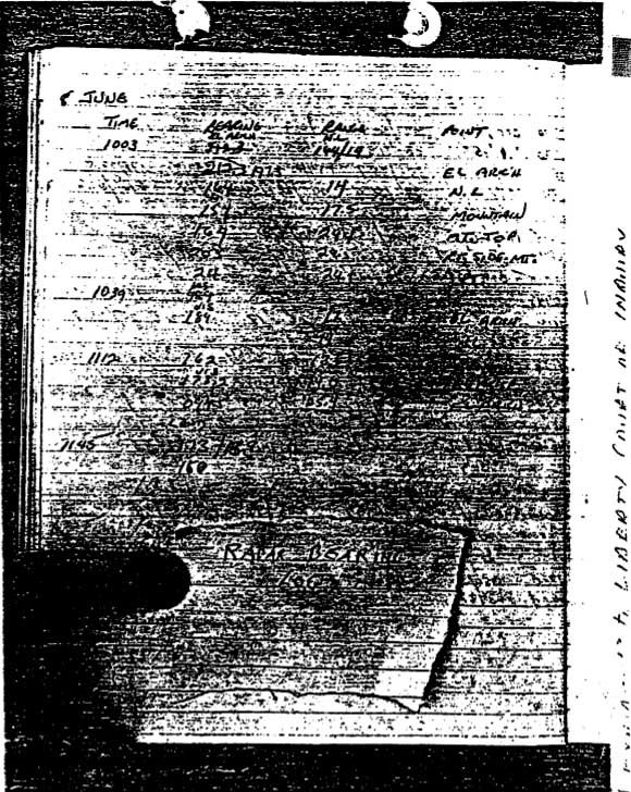
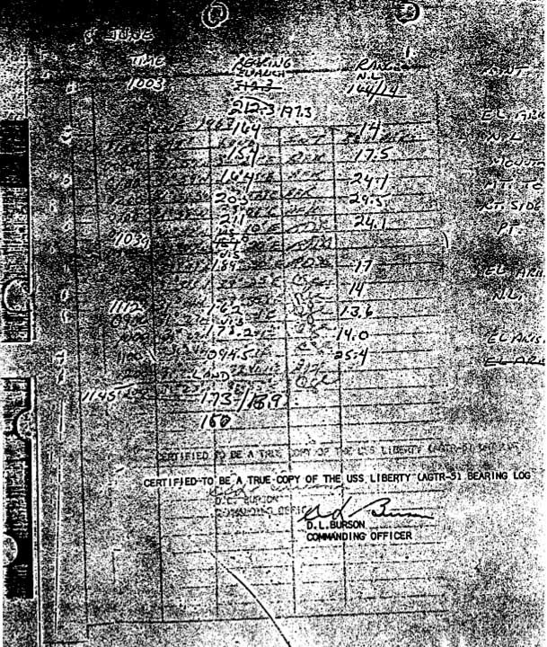
As you can see, these have not held up too well in the copying regimen. The first page is a hand-held photo of the bearing log, with a thumb and a scrap of paper covering half the page. The second is a flat 'scan,' which is more uniformly readable except that it was apparently written on tracing paper which here is over a lat-long graph. It's a bizarre effect, and a bit unprofessional, it seems, for a Navy court of inquiry. Trying to sort it out, I decided the lat-long one runs hourly from 00:00(midnight) through 13:00. Apparently they got distracted sometime before the 1400 entry. It's simply time, lat, long, INT (initials), and ??? column, left blank anyway. A large portion of the entries are obscured, others simply unreadable at this exposure and resolution. And I'm sure the data is available elsewhere and of no huge interest. [Update: K.J. Halliwell's got a perfectly clear copy of this available as the 'dead reckoning chart'here.]
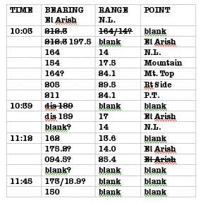 The overlay is the log I'm interested in, without the covering paper or thumb, and we see nothing was missing except "Certified to be a true copy of the USS Liberty (AGR-5) Bearing Log." Transcribed at left, this only shows navigational use of radar - taking bearings on land objects (usually the minaret at El-Arish), and nearest shoreline along that line. Time intervals are apparently ten minutes per line on average, only sporadically labeled, screwy at the beginning. Since the steady course at five knots means one nautical mile was passed every twelve minutes, that may be the interval here. Either way, the last line with no point or range but a bearing of 150, would correspond with 11:50-12:00 depending. End-of-shift sloppiness? I don't see any further logs showing activity in the PM. I'm currently using these to fine tune my map of the route taken, and will post it when complete.
 Capt McGonagle to the NCOI Confirmation that the bearing log from 12:00 on is not "available."
"LTJG PAINTER came onto the bridge after general quarters to assume the watch as the officer of the deck. As he assumed the officer of the deck watch, he indicated that he was having difficulty in obtaining an accurate ship's fix. At that time, and the time was approximately 1400, I personally sighted the Minaret at El Arish to be on a bearing of 142 from the ship and the range as I recall from the radar was approximately 25.5 miles. I do not know that this radar range can be verified from the records available at this time."
For visibility range, we have Ensign David Lucas, who was apparently in charge of surface lookouts, and told the NCOI between 1200 and 1300, “more smoke was visible and the land itself was barely visible. This was through the telescope or high powered binoculars on the 04 level.” Nearest Land was about 20 nm distant, first less then more, during this time. Regarding sightings of ships, which would be more challenging than spotting the edge of a continent:
"[The lookouts] had received refresher training, this was sometime since we left Rota on the 2nd of June, and had been refreshed on reporting all surface contacts to include relative bearing, approximate range, and target angle. Had also been given refreshers on reporting aircraft properly, on elevation, what angle, other factors pertaining to properly reporting all surface and air contacts to the officer of the deck. This had been stressed heavily in the first week in June, before we did reach our operating area.”Officer of the deck's notes [packet 2, pp 3-4] show no reports of surface craft on June 8 prior to the attack. The main deck log does mention two ships sighted June 7, in this same vigilant mode:
1420 sighted unidentified merchant ship bearing 198, distance about 4800 yards. Identified asmerchant ship as Bencleugh, registry unknown. […] 1430 sighted merchant ship Ioanis Asptiotis Greek registry, bearing 019, distance about 1500 yards.These were about 2.37nm and 0.74nm distant. There were almost certainly other ships around further out, but these were apparently too far away to notice or care about. The smaller torpedo boats were first sighted at an estimated distance of 3-4 nm. So lack of visual contact is not much of a problem for a mystery ship unless it was supposed to be less than four miles from Liberty.
But their radar had a range of up to 24.5 miles anyway, judging by ranges given in the chart (I'm pretty sure now my 29.5 above should be 24.5). This was for a large object called "nearest land (N.L.), not a piddling warship. The Liberty's radar did pick up the approaching MTBs at 1351, ten minutes after the latter has detected them, and six minutes prior to the air attack: "1351 [LOG:] 3 SMALL SURFACE CONTACTS HELD ON RADAR 32,000 YARDS BEARING 082T - REPORTED TO BRIDGE AS 3 SURFACE CONTACTS." [Source: MTB Torpedo Attack - testimony].If these smallish boats (about 90 feet long) appeared at this range, a ship of any size then would have to be probably 20 nm away or further to not show on radar.
ATTACK MAPS BASED ON OFFICIAL SOURCES
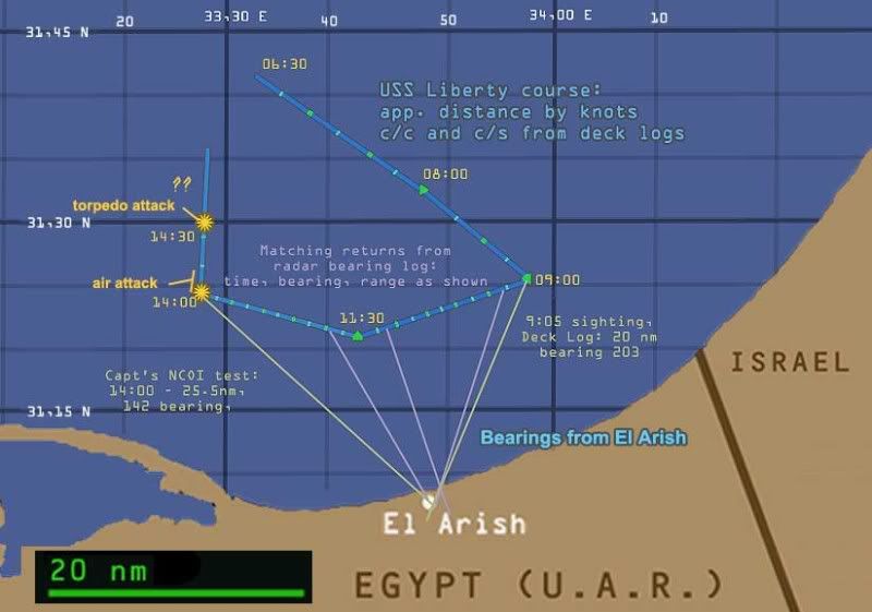 [r-click, new window for full-size view] USS Liberty course from 6 am until the end of the attack. 20 nautical mile scale, land contours from Google maps, lat long intersections set using Earth Tools. Path first set roughly from various graphics. Liberty speed and course changes derived from the Deck Log, lengths of each leg set by knots, marked at 15 min intervals. All approximate, and ignoring small momentary changes. 9:00-11:30 stretch fine-tuned with Liberty's radar bearing log and its readings from El Arish minaret, plus deck log (9:00 entry) and captain's recollection (14:00, as above).
 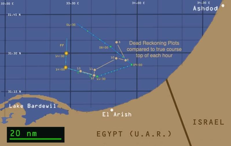 I hoped the plots from the Dead Reckoning Table would help pin down the exact course, but no luck.
 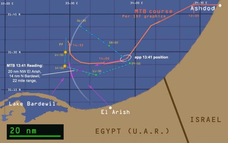 Motor Torpedo boats app. path based on IDF graphics, generally supported by MTB logs. Location of their radar return at 13:41 (inside the magenta triangle) matches the Liberty, but the heading and speed they decided on were way off, which remains an unresolved mystery.


No comments:
Post a Comment