Adam Larson / Caustic Logic
May 25 2009
incomplete
THE PROOF IN THE PUDDING
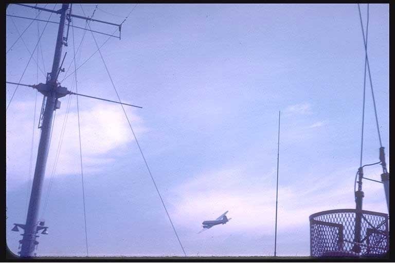 At least one photograph of presumed reconnaissance aircraft (above) has survived and is published on the USS Liberty survivors association image index web page with the following caption:
 Israel says there was no pre-attack reconnaissance. Any aircraft we saw, they say, were high in the sky carrying troops to the battlefield. Not so. Here is an Israeli reconnaissance airplane that circled the ship about an hour before the attack. The pilot was heard reporting to HQ that he saw an American flag and men sunning themselves on deck. [1]First, it does seem to be checking the ship out. It’s quite close, low, passing starboard side to the aft and clearly turning as if to keep circling. This is not a casual disinterested high-alt pass-over. However, that flag-n-sunbathers report is news to me, and so far I see no source aside from this image index. And also I’m pretty sure the time frame “about an hour” before the 1400 attack is wrong.
This photo would perhaps have been taken by Petty Officer Charles Rowley, the ship’s photographer, reportedly in the lab most of the morning during the earlier aircraft recon. [2] It could have been someone else as well. The picture was apparently taken from the aft (rear) portion of the ship, looking back and to their right of the rear antenna mast (visible at left). Its crossbars extend left and right, across the beam, and the small lights (lower corner) are fairly low to the deck, so the camera is apparently at main deck level and pointed up at a moderate angle. At right is a wire mesh thing I can’t locate in photos, and apparently anchoring cables for some antenna. My right-side reference is thus un-anchored. Should be TRSSCOM housing there (Here's a good view of the rear of the ship, seen from the middle - TRSSCOM is the big dish, rear antenna mast behind that).
Anyway, the aircraft is quite close off the port aft, not very high above the waves, banking and turning left. Both the fuselage shadow on left wing and the light falling on the mast and its lights shows the sun is quite high in the sky, meaning, in general, around mid-day. I checked with a solar calculator the lat-long points, date, year, time, and found solar noon on the Liberty's path would fall one second after 11:44 local time. (selecting Cairo, June 8 1967, UTC offset -2, will get you close).
WHAT THE PLANE TELLS US
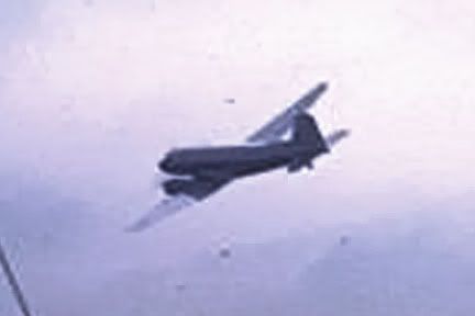
In my previous analysis of aerial reconnaissance reports, I got a general grasp of what different craft are said to have circled the ship. Anywhere near mid-day we first have two delta-wing Mirage fighters orbiting the ship thrice at about 1000 or 1030 (accounts vary). This is clearly not one of those, and both slots seem too early for the sun here. This was followed by two or three visits, at perhaps 1030, and certainly at 1057 and 1126, by a craft thought by the crew similar to a “Flying Boxcar”, and called by its Israeli owners a Noratlas. The two do indeed resemble each other, but not the plane in this photo. So barring a problem with the accepted timeline, this must be after 11:26, and presumably after the subsequent course change at 11:32, where they turned thirty degrees to the north.
The aerial visits after that point are more sketchy for detail, but this photo is said to be “about an hour” before attack, so it could only be the last visit, what Ennes cites as another visit of the “Flying boxcar” at 1245 (second-hand – he was having lunch) [3] But as we’ve established that’s no Noratlas, and it seems the sun is no match for that late in the day either. Jundge Cristol describes a1200 flight, way up at 30,000 feet, and the wrong aircraft to boot; he cites as a “Vatour,” but it would actually be a Vautour, which is French for vulture. [4]
The plane we see here is not a fit with any of the over-flying craft I’m aware of. It’s non-descript, generic, bulky body, low-set wings with engines beneath like any smaller cargo plane or airliner. Something tells me those are propellers, not jet engines. I’m really no plane buff. It is a possible fit with one other reported aircraft never reported close by - [56, 50] a “fat little prop plane, maybe a light bomber” repeatedly traversing the beach, “just skimming the sand dunes.” This was first reported before 0700, with no specific mentions after. But as Ennes noted explosions ashore between 1130 and 1200, he did note “the little bomber that had patrolled the beach all morning could no longer be seen.” [5]
With no other planes besides Noratlas and Mirage jets mentioned before the 1132 turn, this is probably after that but apparently not much after. The next plane alleged is 11:45, a fit for the time of the explosions. This is one of the less verified, only mentioned in a list in the Salans Memo with no details (see previous post, link above). Who saw what plane do what at that time? Ennes was officer of the Deck, and would have seen such a plane, but there is no mention in his book, just the Noratlas again in his absence at 1215 and 1245. [6] Wrong plane and time for this case. Again with the time, how do I know what time it is here?
WHAT THE EGYPTIAN SUN TELLS US
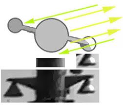 11:45 is one minute past local solar noon, with the sun at its highest elevation (82° above the horizon, so nearly overhead). and with an azimuth (direction to sun) of 180° - due south. First I presumed this was after the 11:32 course change, so I set my model on a 283 heading and set to narrowing down the solar azimuth angle which helps me get a close time estimate. I found the light angle, approximate, from the rear mast (lower left corner) by analyzing light fall-off around the mast’s curve and and shadow patterns on its attached lights. They indicated one general direction, which I marked with arrows – some to and some from the sun, whatever.
 This I pasted back on the ship at the proper angle (not to scale, that doesn’t matter). To hit the mast at that angle with the ship at 283 true, the azimuth would be somewhere around 168, or in a range of, say, 162-174. This is consistent with a general noon-ish time frame indicated by the high solar elevation. And the Azimuth is much better at setting time - the change I'm seeing here is close to one degree per minute!
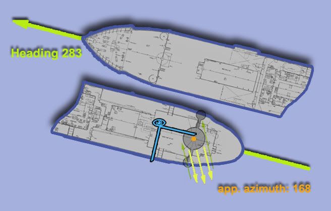
The exact minute is not to be taken too literally given the margins of error in each step – but the resultant azimuth range for a 162-174 spread is between 1132-1141 local time. I simply can’t see anything outside this range explaining that photo. Either this is Ennes’ 1126 misidentified “flying boxcar” (and the Captain’s 1126 “unidentified”), lingering quite a bit, or it’s the unknown rounded-to-1145 plane that Ennes missed as he wrapped up his shift.


1 comment:
The analyzed image does not show an IDF recon aircraft on the day of the attack. For analysis see: https://sites.google.com/site/usslibertyinquiry/essay29a
Post a Comment